Sea of Trees
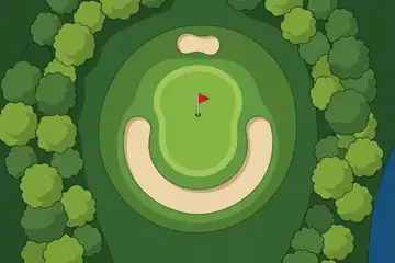
Fairways cut through deep woods: the picture every golfer knows, and a real forest to match.
Where it is
Sea of Trees is the course the game began with, and it is not a portrait of one place. It is the classic parkland course: green fairways between walls of trees, a pond here, a stream there. For its map course we chose a real forest with the right name for the job, the Black Forest of south-western Germany.
The Black Forest, Schwarzwald in German, is a range of wooded mountains in Baden-Württemberg, running along the east side of the Rhine valley. The name is old and comes from the darkness of its dense conifers. Its highest point is the Feldberg at 1,493 metres. The two small rivers that join to form the Danube rise on its eastern slope.
The region is known for cuckoo clocks, for farmhouses with enormous roofs, and for the cherry cake that carries its name.
The picture course
The painted course is drawn in the plain, friendly style of a course guide: several shades of green for rough, fairway and green, round-topped trees packed along the edges, sand in pale cream and water in a flat blue. The holes use every classic idea once: a lake down the left of the opening hole, a dogleg, a green ringed by a horseshoe bunker, a stream to cross, and a short hole to a green that sits out in a lake at the end of a narrow walkway.
Par 72 over 6,005 m: 4 par threes, 10 par fours and 4 par fives. The front nine is par 36 (2,965 m) and the back nine par 36 (3,040 m). The longest hole is number 18, a par 5 of 505 m; the shortest is number 12, a par 3 of 145 m.
| Hole | 1 | 2 | 3 | 4 | 5 | 6 | 7 | 8 | 9 |
|---|---|---|---|---|---|---|---|---|---|
| Par | 4 | 4 | 3 | 5 | 4 | 4 | 3 | 4 | 5 |
| m | 330 | 300 | 165 | 480 | 361 | 274 | 185 | 420 | 450 |
| Hole | 10 | 11 | 12 | 13 | 14 | 15 | 16 | 17 | 18 |
| Par | 4 | 4 | 3 | 5 | 4 | 4 | 3 | 4 | 5 |
| m | 340 | 315 | 145 | 495 | 370 | 290 | 175 | 405 | 505 |
The map course: 9 pins
The map course is played on the real map, from one real place to the next: 9 pins, par 36, 250 km from the first tee to the last pin. Distances are real kilometres; the pictures of the holes are satellite views.
Route of the map course: the tee (T) and the pins in playing order.
- Tee · Waldshut stationStation
The tee is at the railway station of Waldshut, a town on the Rhine at the forest's southern edge.
- 1 · BräunlingenTown · 38.3 km · Par 4
A small town on the high plateau east of the mountains.
- 2 · Triberg WaterfallsWaterfall · 27.3 km · Par 4
A chain of cascades in the town of Triberg, among the highest waterfalls in Germany.
- 3 · HochburgSight · 24.3 km · Par 4
The ruin of a large castle on a hill near Emmendingen.
- 4 · FeldbergMountain · 28.1 km · Par 4
The highest summit of the Black Forest, 1,493 m, bare on top above the tree line.
- 5 · Bonndorf im SchwarzwaldTown · 26.0 km · Par 4
A town of the southern forest, near the gorge of the river Wutach.
- 6 · MagdalenenbergSight · 26.1 km · Par 4
A burial mound of the early Iron Age near Villingen, one of the largest of its time in central Europe.
- 7 · ElzachTown · 31.2 km · Par 4
A town in the valley of the river Elz.
- 8 · Europa-ParkResort · 28.0 km · Par 4
The big theme park at Rust, down on the Rhine plain.
- 9 · KaiserstuhlMountain · 21.0 km · Par 4
A small range of volcanic hills that stands alone in the Rhine plain, covered in vineyards.
Par and distances are the game's own course data. The pins are real places listed in Wikidata; what is said about them is kept to well-known facts.
Travel notes
The forest is green from late spring, at its most colourful in autumn, and under snow on the high ground in winter. The things that stay the same are the long views from the Feldberg, the waterfalls at Triberg, the lakes left by old glaciers, and village after village of timbered houses.
More courses
Sources: Black Forest · Feldberg (Black Forest) · Triberg Waterfalls · Danube · Magdalenenberg · Kaiserstuhl (Baden-Württemberg) · Europa-Park · Hochburg · Waldshut station · Bräunlingen · Bonndorf im Schwarzwald · Elzach · Wikidata (CC0)