Snowfield
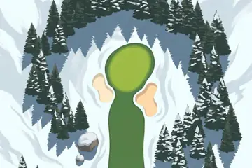
Fir forest, frozen lakes and the Sea of Okhotsk: the snow country of Japan's far north-east.
Where it is
Eastern Hokkaido is the cold corner of Japan. Its north shore faces the Sea of Okhotsk, and in the depth of winter drift ice comes down from the north and reaches the coast around Abashiri, about as far south as sea ice is seen anywhere in the northern hemisphere.
East of Abashiri the Shiretoko Peninsula runs out into the sea, a ridge of volcanoes so wild that it was made a UNESCO World Heritage Site in 2005. Inland lie the caldera lakes of Akan-Mashu National Park. Lake Akan is known for marimo, velvety green balls of algae that grow on its bed.
The city of Kitami, which gives the first hole of the painted course its name, sits in a farming basin between the coast and the mountains.
The picture course
The painted course is white on white: snowfields with soft blue shadows, and the fairways the only green in the picture. Dark firs and one grove of bare birches frame the holes. The second hole asks for a carry over a frozen lake with cracks drawn across the ice; later a black ravine with a wooden bridge cuts through the round, boulders wear caps of snow, and a wall of blue ice leans over one fairway. Near the end a steaming turquoise pool stands beside the green, and the last hole is lit orange by the evening sun.
Par 72 over 6,295 m: 4 par threes, 10 par fours and 4 par fives. The front nine is par 36 (3,170 m) and the back nine par 36 (3,125 m). The longest hole is number 9, a par 5 of 545 m; the shortest is number 3, a par 3 of 165 m.
| Hole | 1 | 2 | 3 | 4 | 5 | 6 | 7 | 8 | 9 |
|---|---|---|---|---|---|---|---|---|---|
| Par | 4 | 4 | 3 | 4 | 5 | 4 | 3 | 4 | 5 |
| m | 340 | 340 | 165 | 370 | 500 | 390 | 180 | 340 | 545 |
| Hole | 10 | 11 | 12 | 13 | 14 | 15 | 16 | 17 | 18 |
| Par | 4 | 4 | 3 | 5 | 4 | 3 | 4 | 4 | 5 |
| m | 370 | 370 | 170 | 545 | 360 | 175 | 330 | 330 | 475 |
The map course: 9 pins
The map course is played on the real map, from one real place to the next: 9 pins, par 38, 324 km from the first tee to the last pin. Distances are real kilometres; the pictures of the holes are satellite views.
Route of the map course: the tee (T) and the pins in playing order.
- Tee · Rausu LighthouseLighthouse
The round starts from a lighthouse at Rausu, on the eastern shore of the Shiretoko Peninsula.
- 1 · Mount ShariMountain · 50.3 km · Par 5
A volcano of 1,547 m at the base of the Shiretoko Peninsula, counted among the hundred famous mountains of Japan.
- 2 · Nakashibetsu AirportAirport · 28.6 km · Par 4
The airport of the dairy plains at the far eastern end of Hokkaido.
- 3 · Isobunnai StationStation · 39.5 km · Par 4
A small railway station in the town of Shibecha.
- 4 · Akanko OnsenSight · 37.8 km · Par 4
The hot spring town on the shore of Lake Akan.
- 5 · KitamiTown · 44.1 km · Par 5
The city of the inland basin, and the name of the first hole of the painted course.
- 6 · Memanbetsu AirportAirport · 23.3 km · Par 4
The airport that serves Abashiri and Kitami.
- 7 · Port of AbashiriPort · 18.6 km · Par 3
The harbour of Abashiri on the Sea of Okhotsk, the coast the drift ice reaches in winter.
- 8 · Sakura FallsWaterfall · 37.7 km · Par 4
A waterfall inland from the Okhotsk coast.
- 9 · Chūrui IslandIsland · 44.3 km · Par 5
An island in Lake Akan, the lake of the marimo.
Par and distances are the game's own course data. The pins are real places listed in Wikidata; what is said about them is kept to well-known facts.
Travel notes
Winter is the season this course is about: the sea ice is usually there in the coldest weeks of the year, and the lakes freeze over. Summer is short, green and cool, with flowers along the coast. The volcanoes, the caldera lakes and the long empty shore do not depend on the season.
More courses

Sources: Hokkaido · Sea of Okhotsk · Shiretoko National Park · Akan Mashu National Park · Lake Akan · Marimo · Abashiri · Kitami · Mount Shari · Nemuro Nakashibetsu Airport · Isobunnai Station · Memanbetsu Airport · Wikidata (CC0)