Maldives Atolls
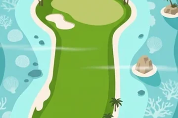
Rings of coral in the Indian Ocean: on the map course every hole is a carry over open water.
Where it is
The Maldives are a chain of coral atolls in the Indian Ocean, south-west of India and Sri Lanka. There are about 26 natural atolls and well over a thousand islands, strung along a line that crosses the equator. The English word "atoll" itself comes from the Maldivian language, Dhivehi.
An atoll is a ring of reef around a lagoon, grown on top of a volcano that sank long ago. The islands that sit on the ring are small and flat, and the country is the lowest-lying in the world: most of its land is only a metre or two above the sea. Inside the lagoons the water is shallow and pale; outside the reef it drops quickly to deep blue.
The map course plays through the middle of the chain: Ari Atoll, and the two Nilandhe atolls to its south, which the country's administration calls Faafu and Dhaalu.
The picture course
The painted course is drawn in clean flat colour: turquoise sea, a paler ring of lagoon around every island, and a rim of white sand. Each hole is its own sandbank with palms along the edge; coral heads, turtles, rays and small sailing boats fill the water. On several holes the fairway is broken into two or three islands, so the ball has to fly the gap. The eighteen holes are named after the atolls of the country.
Par 72 over 5,986 m: 4 par threes, 10 par fours and 4 par fives. The front nine is par 38 (3,215 m) and the back nine par 34 (2,771 m). The longest hole is number 7, a par 5 of 505 m; the shortest is number 13, a par 3 of 165 m.
| Hole | 1 | 2 | 3 | 4 | 5 | 6 | 7 | 8 | 9 |
|---|---|---|---|---|---|---|---|---|---|
| Par | 4 | 4 | 4 | 4 | 5 | 4 | 5 | 4 | 4 |
| m | 326 | 283 | 425 | 282 | 490 | 326 | 505 | 224 | 354 |
| Hole | 10 | 11 | 12 | 13 | 14 | 15 | 16 | 17 | 18 |
| Par | 3 | 4 | 5 | 3 | 4 | 4 | 3 | 3 | 5 |
| m | 200 | 248 | 503 | 165 | 351 | 425 | 200 | 176 | 503 |
The map course: 9 pins
The map course is played on the real map, from one real place to the next: 9 pins, par 27, 150 km from the first tee to the last pin. Distances are real kilometres; the pictures of the holes are satellite views.
Route of the map course: the tee (T) and the pins in playing order.
- Tee · Alif Alif AtollIsland
The tee is in Alif Alif, the northern half of Ari Atoll.
- 1 · ThudufushiIsland · 13.0 km · Par 3
A small island in Alif Dhaal, the southern half of Ari Atoll.
- 2 · MirihiIsland · 19.3 km · Par 3
Another island of Alif Dhaal, a short hop over the lagoon.
- 3 · Maamigili AirportAirport · 17.7 km · Par 3
The airport on Maamigili, at the southern tip of Ari Atoll.
- 4 · KandoomoonufushiIsland · 18.5 km · Par 3
An island in Faafu Atoll, reached across the channel that separates it from Ari.
- 5 · Feeali LighthouseLighthouse · 12.7 km · Par 3
A lighthouse on Feeali, one of the islands of Faafu.
- 6 · BileddhooIsland · 16.9 km · Par 3
An island on the rim of Faafu Atoll.
- 7 · Faafu AtollIsland · 14.1 km · Par 3
The atoll itself, also called Northern Nilandhe: one of the hole names of the painted course.
- 8 · Nilandhoo LighthouseLighthouse · 20.0 km · Par 3
A lighthouse at Nilandhoo. At 20 km this is the longest carry of the round.
- 9 · BandidhooIsland · 17.4 km · Par 3
An island of Dhaalu, the atoll to the south, where the round ends.
Par and distances are the game's own course data. The pins are real places listed in Wikidata; what is said about them is kept to well-known facts.
Travel notes
The Maldives are warm all year. The north-east monsoon brings the drier, calmer months and the south-west monsoon the wetter ones. What people come for is in the water: the reefs, and the big animals that pass through the channels between the atolls. The southern edge of Ari Atoll is known for whale sharks.
More courses


Sources: Maldives · Atolls of the Maldives · Atoll · Ari Atoll · Faafu Atoll · Dhaalu Atoll · Alif Alif Atoll · Thudufushi · Mirihi · Villa International Airport Maamigili · Bileddhoo · Bandidhoo · Wikidata (CC0)