Lake Natron
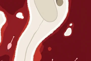
A shallow soda lake on the floor of the East African Rift, red in the dry season and home to flamingos.
Where it is
Lake Natron lies in northern Tanzania, right against the Kenyan border, on the floor of the Gregory Rift, the eastern arm of the East African Rift. It is a soda lake: water arrives from the Ewaso Ng'iro river and from mineral hot springs, but nothing flows out, so evaporation leaves the salts behind. The lake is only a few metres deep and its water is strongly alkaline.
In the dry season salt-loving microorganisms multiply and tint the water red and orange, while a pale crust of soda forms along the shore. Few animals can live with water like this, and that is exactly why lesser flamingos nest here: the lake is the main regular breeding ground of the species in East Africa, and the birds build small mud mounds on the flats far from predators.
Just south of the lake stands Ol Doinyo Lengai, whose name means "Mountain of God" in the Maasai language. It is known among geologists as the one active volcano that erupts natrocarbonatite, a dark, runny lava that turns white as it weathers.
The picture course
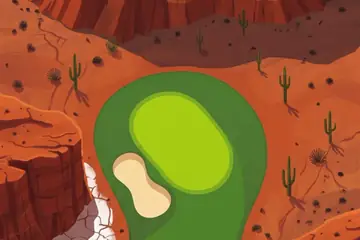
The painted course turns the usual colours of golf upside down. The water is crimson and the playing surface is the pale cream of the soda crust, drawn in flat, poster-like shapes. Flocks of pink flamingos stand in the shallows or fly across the fairway, and several holes run between fields of round nest mounds. Later holes add black lava tongues, a grey ash fall and one startling band of green where a river reaches the lake.
Par 71 over 5,665 m: 4 par threes, 11 par fours and 3 par fives. The front nine is par 36 (2,726 m) and the back nine par 35 (2,939 m). The longest hole is number 18, a par 5 of 545 m; the shortest is number 3, a par 3 of 99 m.
| Hole | 1 | 2 | 3 | 4 | 5 | 6 | 7 | 8 | 9 |
|---|---|---|---|---|---|---|---|---|---|
| Par | 4 | 4 | 3 | 5 | 4 | 4 | 3 | 4 | 5 |
| m | 341 | 221 | 99 | 455 | 292 | 359 | 162 | 372 | 425 |
| Hole | 10 | 11 | 12 | 13 | 14 | 15 | 16 | 17 | 18 |
| Par | 4 | 4 | 3 | 4 | 4 | 4 | 3 | 4 | 5 |
| m | 376 | 389 | 136 | 230 | 388 | 373 | 151 | 351 | 545 |
The map course: 9 pins
The map course is played on the real map, from one real place to the next: 9 pins, par 39, 319 km from the first tee to the last pin. Distances are real kilometres; the pictures of the holes are satellite views.
Route of the map course: the tee (T) and the pins in playing order.
- Tee · Loliondo AirstripAirport
The round begins at an airstrip near Loliondo, a small town in the highlands west of the lake.
- 1 · NdasegeraMountain · 20.4 km · Par 4
A mountain in northern Tanzania, on the high ground above the rift.
- 2 · PeninjSight · 49.1 km · Par 5
A site on the western side of the lake where a jaw of the early hominin Paranthropus boisei was found in 1964; it is a national historic site of Tanzania.
- 3 · Magadi AirportAirport · 55.0 km · Par 5
The airstrip of Magadi, the soda-mining town across the border in Kenya. The longest hole of the course.
- 4 · Nguruman EscarpmentMountain · 35.1 km · Par 4
The steep western wall of the rift valley on the Kenyan side.
- 5 · Lake MagadiSight · 29.2 km · Par 4
Natron's northern neighbour in Kenya, another soda lake, where the mineral trona is harvested from the lake bed.
- 6 · Ol Doinyo SambuMountain · 48.6 km · Par 5
A volcano of the rift near the border between the two lakes.
- 7 · Lake NatronSight · 30.6 km · Par 4
The lake itself: the pin stands on its soda flats.
- 8 · Gelai VolcanoMountain · 25.1 km · Par 4
An old volcano that rises over the south-eastern shore of the lake.
- 9 · Ol Doinyo LengaiMountain · 26.1 km · Par 4
The "Mountain of God", the active volcano south of the lake, and the last pin of the round.
Par and distances are the game's own course data. The pins are real places listed in Wikidata; what is said about them is kept to well-known facts.
Travel notes
The colour of the lake is strongest in the dry months, when the water is low. Flamingo breeding follows the rains and is not the same every year. The classic sights here do not change: the red water seen from above, the white cone of Ol Doinyo Lengai, and the escarpment walls of the rift. It is a hot, remote area with long distances between settlements.
More courses
Sources: Lake Natron · Ol Doinyo Lengai · Lesser flamingo · Gregory Rift · Lake Magadi · Peninj Mandible · Loliondo Airstrip · Peninj · Magadi Airport · Nguruman Escarpment · Gelai Volcano · Wikidata (CC0)